Tuesday, May 10, 2016
No blog for May
There will be no state park visit for the month of May. The blog has continued for one year and may end with April as my last written report; I shall continue to travel to the parks since I love my time outdoors.
Monday, April 11, 2016
Big Bend Ranch State Park
In April, we visited Big Bend Ranch State Park. My husband
and I stopped at the Barton Warnock Visitor’s Center, where they sell daily
passes to the state park plus Big Bend National Park. Both are huge parks and
are popular places to visit, even on weekdays, like the day we arrived. We
didn’t stop by the office within the park; the trip required driving 27 miles
on a dirt road with a suggested speed limit of 25 mph.


The visitor’s center had a lovely desert garden that
was 2.5 acres; we enjoyed the stroll around it and took pictures before moving
on. The tree on the right is a Parkinsonia aculeata.
In 1988 the state of Texas acquired the Big Bend Ranch,
which covers over 300,000 acres. It was purchased from Robert O. Anderson, who
became the largest private land owner in the United States in 1969 when he
bought the property and begin running it as the Diamond A Cattle Company. He
partnered with Walter Mitchell when it became a hunting preserve (in the
1980’s). The park operated on a limited basis in 1991. In 2007, it fully opened
to the public as Big Bend Ranch State Park.
The city of Lajitas is located along the park road. We drove six-tenths of a mile going from city signs at both ends of the little town. Another thing that caught my interest was a sign I saw a few times; it warned motorists of “loose livestock”. There are cattle farms inside the park and the owners are allowed ‘free range’ grazing in the park. Due to this policy, cattle could wander in front of vehicles. Some are Longhorns but we didn’t see any cattle.
The city of Lajitas is located along the park road. We drove six-tenths of a mile going from city signs at both ends of the little town. Another thing that caught my interest was a sign I saw a few times; it warned motorists of “loose livestock”. There are cattle farms inside the park and the owners are allowed ‘free range’ grazing in the park. Due to this policy, cattle could wander in front of vehicles. Some are Longhorns but we didn’t see any cattle.


I also read instructions about taking along a minimum
of a gallon of water when hiking. That seemed like a common recommendation in
state parks with long walking trails.
 |
| Above is a photo taken from the trail and below is the Rio Grande. |

My usual trash pick up was along the Voodoo trail; I found very little during the hike.
I waded in the Rio Grande River while in the park and knew that Mexico was on the other side of the river (the water was chilly in April).
We saw signs advertising kayaking and rafting in the Rio Grande: summer pastimes. Long distance mountain bikers would find a paradise for peddling around FM 170, the main park road. And, individuals who like roughing it while camping would find a wonderful park for tent camping. Although I’m sure summers in this desert climate are tough on the tent campers.
Thursday, March 10, 2016
San Angelo State Park
March is San Angelo State Park month. We started out
at the South Shore of San Angelo Park, planning to move on to the North Shore
later.
Unfortunately, the park volunteer at the front desk
informed me that the season for rainbow trout was on it’s way out. I’d love to
catch a decent size trout and the park handout stated they do have fishing
equipment to loan out. But, since late winter isn’t the best time to catch them,
I decided not to fish. Javelina Pond is the place to fish at San Angelo State Park,
since it’s stocked on a regular basis. O.C. Fisher Lake is normally the
swimming and boating area. The lake was at 16 percent capacity during our
visit, due to lack of rain in recent years.
 |
| O.C. Fisher Lake above and Burkett Trail below. |

Although we only walked on the Burkett multi-use trail, there are over 50 miles of biking, walking and horse trails in the park. We saw bikers, walkers, and a jogger, but no horses. Those bringing their horses to the park can leave them at the equestrian area not far from the beginning of the path we walked along. Horses can also be tethered next to some of the campsites.
Bison and Longhorn cattle can be seen in the fenced areas of this park (if one is lucky). Both the bison and some of the Longhorn cattle are part of Official State of Texas Longhorn and Texas Bison herds given to the state in the early 1900’s. We just observed bison, but they were too far away to take a picture of since I didn’t have a telephoto lens. Lesson learned: bring along a camera with a telephoto lens if you want a picture of fenced animals.
I saw the outside of six small cabins that have
electricity, a microwave, refrigerator and sleeping space for six. There’s also
a bunkhouse–which also sleeps six. It’s roomier and has a bathroom.
Some of the trailer sites at this park are reserved
for a full month’s time rather than the usual two week limit. The decision to
open the sites for a longer period of time was useful to those who temporarily
moved into the area due to jobs in the oil fracking industry.I took a picture of burned trees and grass in the park. This burning was deliberately done to eliminate grass, cactus plants, and mesquite trees.

 |
| Above is a beautiful set of playground at the South Entrance and below is the tent discussed below. |

After leaving South Shore, we traveled about 9 miles
to reach the North Shore entrance. Upon arrival, there was no one at the check-in
gate. A park ranger stopped by as we wandered around the entrance and checked
our yearly park pass. If no one is at the gate, visitors are expected to put
the $4.00 entrance fee in the drop box.
We saw an unusual home while exploring this part of
San Angelo Park. A tent owner had a tarp over his/her tent and another one around
the picnic table. Perhaps for protection from wind and rain? Since no people
were seen at either the tent or the trailer in the same camping area, we were
unable to ask questions about the eye-catching large tent with a pirate flag
displayed next to the tent exterior. There was no activity around this part of
the park at all on this late winter day.
 |
| As usual, I picked up trash. There wasn't much: a can, a bottle and paper. |
Monday, February 1, 2016
Lockhart State Park
February’s park combines all the benefits of visiting
a state park plus a day at the golf course for those who enjoy the sport. Yes,
my husband and I played golf at scenic Lockhart State Park in December of 2015!
I went in December for two reasons. Reason one: we were in the area and I don’t
like to camp in cold weather but wanted to keep up the blog-a-month during
winter months. Two: it was an unusually warm day with Christmas right around
the corner; what better day for golfing?

I also walked over to the swimming pool area, an easy
walk from the front office/check-in building. The original stone walls built by
the Civilian Conservation Corps (CCC) still exist around the pool area but the first
pool was replaced in the 1970’s. There was no water in the pool but it will be
filled before re-opening, around Memorial Day, and will be an ideal place to
cool off then.

Before leaving Lockhart State Park, I took a picture of a CCC building that I was told is now being used as the park director’s residence.
Knowing I would be there for only a day, I still picked
up a trail map–and a couple of other handouts–at the front office. The trails
were all noted on this map as well as the five pools along the spring fed Clear
Fork Creek. The creek is supposed to be a good spot to catch bass, catfish and
sunfish.

 |
| The Entrance sign isn't clear since the picture was taken mid-day. The golf carts we rented were parked a short distance from the front office building. |
Going back to my ‘to-do-list-at-Lockhart’, my husband
and I quickly rented a golf cart and started down the course. We had hardly any
company while playing the game since it was a weekday. That was great since it
was a challenging 9 holes for me.
After golfing, I took a walk down one of the shorter
trails. The one I chose, the CCC Trail, was a winding, very hilly trail. I was
glad the trail only covered .08 of a mile. There was a handrail along the first
part of the walk that I used and stone steps on the path were constructed by
the CCC workers back in the 1930’s. The trail started at a trailer camping area
and ended at the golf course.
 |
| The beginning and end of the rugged CCC trail. |
Looking for other activities, I noticed another handout
for park visitors titled “Public Programs”. It included archery lessons that were
part of a Homeschool Series for ages 10 through 18 years old. I’m sure the
front office would be glad to tell anyone interested if these public programs
continue in 2016.
I didn’t pick up trash at this park. I saw no trash on
the golf course, where I spent most of my time.Before leaving Lockhart State Park, I took a picture of a CCC building that I was told is now being used as the park director’s residence.
 |
| I applaud the state parks for keeping up these CCC buildings. I'm sure it requires hard work to maintain them. |
This is a park worth visiting, especially if you’re a
golfer, even a real amateur like I am. In the summer, it would be an adventure to take
in a golf game in the morning and a swim in the pool in the afternoon. Swimming
and golf on a warm day? What a plan as I sit in front of my computer on a cold
winter day…
In March, it will likely be warm while I’m enjoying
another Texas state park.
Friday, January 1, 2016
Bastrop State Park
January’s park is Bastrop State Park. When I talked to
park employees at the front office, one of the first thing I heard about was
the “Lost Pines” that are found in the park. They’re actually Loblolly Pines,
the same type of trees found over 100 miles east of Bastrop Texas. These trees
grow very well, despite adapting to about 30 percent less rainfall in the
Bastrop area. A wildfire destroyed much of the plant life at this park in 2011.
There are still dead trees and partially fire damaged ones in the park. Not
only was there loss of wildlife and plants, but two people who lived in the
area lost their lives. According to the park employees, one lady died when
going back to rescue her horse and a man died attempting to go back for a tool
box.


This Administration building is near the cabins. The signs are in front of both dying and new growth.
I expected to see a sad sight with just grass
remaining since I was aware of the fire that raged through the area despite
firefighters fighting the blaze. Instead, I saw healthy trees remaining and
newly planted pines along with trees just growing on their own–as they do in
any forest. These new trees, along with those not destroyed by the fire,
convinced me that they will thrive and make the area even more beautiful for
those who love walking or driving through forest lands.
Bastrop State Park had a ten acre lake–Bastrop Lake–that
disappeared after a dam failure last Memorial Day weekend. The water all
escaped the area, much of it ending up in the Colorado River. Eight inches of
rain fell in one hour and flooded the lake to the point that it destroyed the
dam and caused the water to drain within days of the dam breaking. During my
visit to Bastrop, I observed engineers working in the dry area where the lake
once was, studying how to bring this lake back again.

 |
Danger signs are above the site of the former Bastrop Lake and Lake Mina in the photo below.
|
Lake Mina was the second small lake at Bastrop and now
is the only lake. I was informed that it’s a good fishing spot.
The Civilian Conservation Corps (CCC) constructed many
buildings at Bastrop State Park. Cabins built by these CCC workers are still
available for rent at the park. Cabins 1-5 and thirteen are built of stone
while 6-12 and fourteen are log cabins. All were constructed of native
materials. I stayed in cabin one: just viewing the exterior and interior stone
and carving around the fireplace was worth the modest price charged for the
rental property.
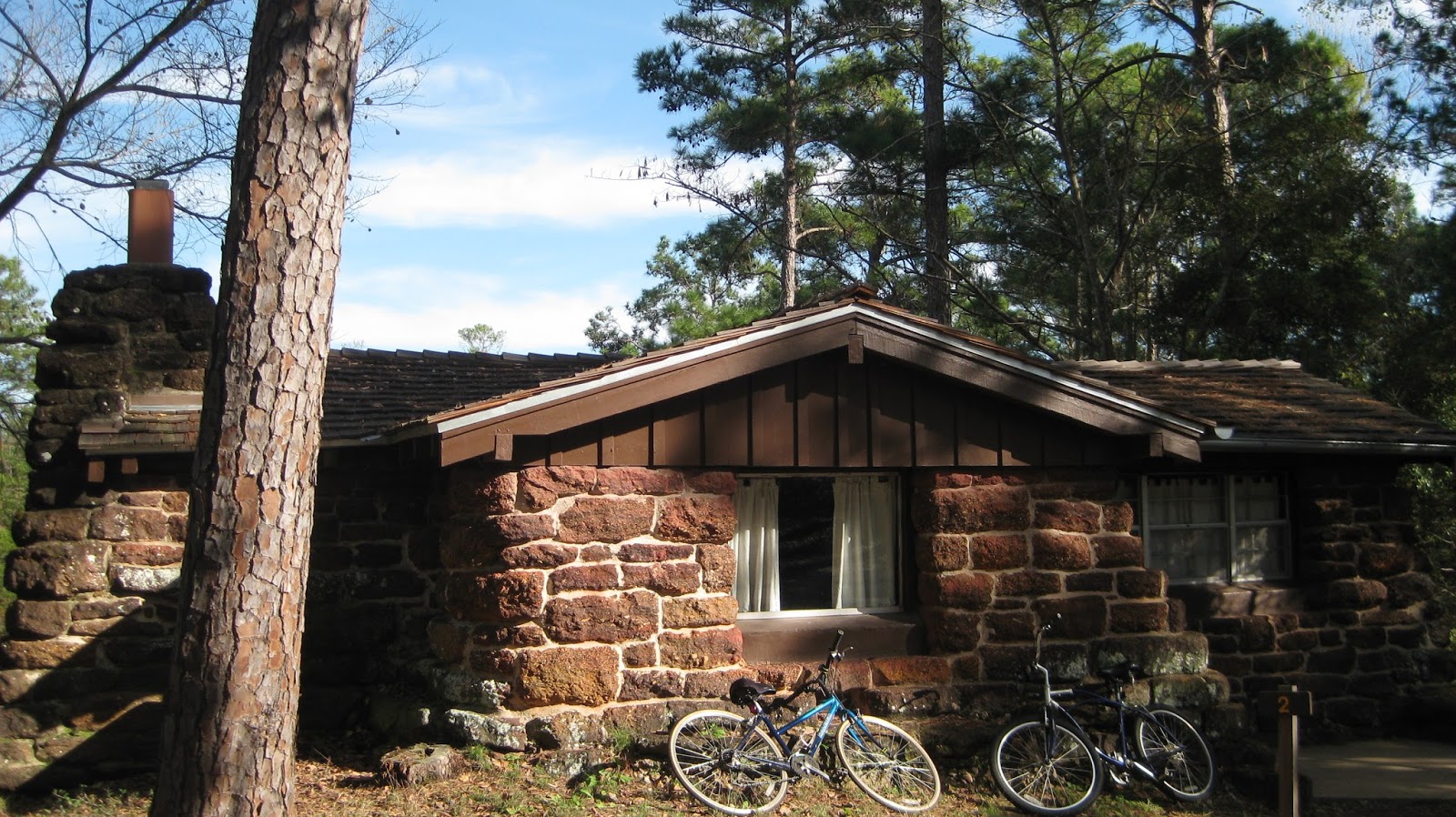
Cabin one with our park transportation in front of the beautiful scene.
I found little trash when looking for items to pick up
during this usual part of my park visit. Although I picked up trash, I failed
to take a picture of it.
While on the subject of trash, it’s worth mentioning
the recycling efforts. Bastrop has the best recycling program I’ve run into at
any of the Texas parks I visited. Plastic bags are available at the front desk
and park visitors are encouraged to take one to dispose of recyclable items
(such as cans, paper, plastics and glass) while enjoying the park. There was a
separate trash can in the cabin for recycling purposes also. I applaud the park
employees who adopted this program and hope to see the idea spreading to all
Texas parks.
As usual, I loved this Texas park and was sad to be
leaving so soon.
Subscribe to:
Posts (Atom)