Monday, February 1, 2016

Lockhart State Park

February’s park combines all the benefits of visiting a state park plus a day at the golf course for those who enjoy the sport. Yes, my husband and I played golf at scenic Lockhart State Park in December of 2015! I went in December for two reasons. Reason one: we were in the area and I don’t like to camp in cold weather but wanted to keep up the blog-a-month during winter months. Two: it was an unusually warm day with Christmas right around the corner; what better day for golfing?

Knowing I would be there for only a day, I still picked up a trail map–and a couple of other handouts–at the front office. The trails were all noted on this map as well as the five pools along the spring fed Clear Fork Creek. The creek is supposed to be a good spot to catch bass, catfish and sunfish.

The Entrance sign isn't clear since the picture was taken mid-day. The golf carts we rented were parked a short distance from the front office building.
  I also walked over to the swimming pool area, an easy walk from the front office/check-in building. The original stone walls built by the Civilian Conservation Corps (CCC) still exist around the pool area but the first pool was replaced in the 1970’s. There was no water in the pool but it will be filled before re-opening, around Memorial Day, and will be an ideal place to cool off then.

Going back to my ‘to-do-list-at-Lockhart’, my husband and I quickly rented a golf cart and started down the course. We had hardly any company while playing the game since it was a weekday. That was great since it was a challenging 9 holes for me.
After golfing, I took a walk down one of the shorter trails. The one I chose, the CCC Trail, was a winding, very hilly trail. I was glad the trail only covered .08 of a mile. There was a handrail along the first part of the walk that I used and stone steps on the path were constructed by the CCC workers back in the 1930’s. The trail started at a trailer camping area and ended at the golf course.
The beginning and end of the rugged CCC trail.
Looking for other activities, I noticed another handout for park visitors titled “Public Programs”. It included archery lessons that were part of a Homeschool Series for ages 10 through 18 years old. I’m sure the front office would be glad to tell anyone interested if these public programs continue in 2016.
I didn’t pick up trash at this park. I saw no trash on 
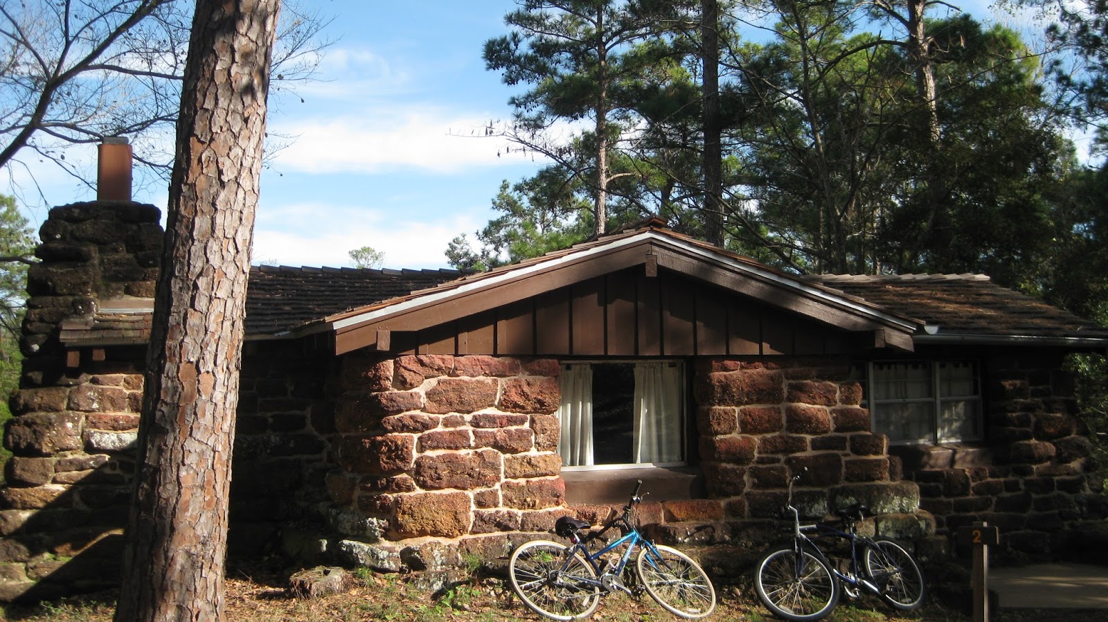
the golf course, where I spent most of my time.
Before leaving Lockhart State Park, I took a picture of a CCC building that I was told is now being used as the park director’s residence.
I applaud the state parks for keeping up these CCC buildings. I'm sure it requires hard work to maintain them.
This is a park worth visiting, especially if you’re a golfer, even a real amateur like I am. In the summer, it would be an adventure to take in a golf game in the morning and a swim in the pool in the afternoon. Swimming and golf on a warm day? What a plan as I sit in front of my computer on a cold winter day…
 
In March, it will likely be warm while I’m enjoying another Texas state park.

Friday, January 1, 2016

Bastrop State Park


January’s park is Bastrop State Park. When I talked to park employees at the front office, one of the first thing I heard about was the “Lost Pines” that are found in the park. They’re actually Loblolly Pines, the same type of trees found over 100 miles east of Bastrop Texas. These trees grow very well, despite adapting to about 30 percent less rainfall in the Bastrop area. A wildfire destroyed much of the plant life at this park in 2011. There are still dead trees and partially fire damaged ones in the park. Not only was there loss of wildlife and plants, but two people who lived in the area lost their lives. According to the park employees, one lady died when going back to rescue her horse and a man died attempting to go back for a tool box.
This Administration building is near the cabins. The signs are in front of both dying and new growth.
I expected to see a sad sight with just grass remaining since I was aware of the fire that raged through the area despite firefighters fighting the blaze. Instead, I saw healthy trees remaining and newly planted pines along with trees just growing on their own–as they do in any forest. These new trees, along with those not destroyed by the fire, convinced me that they will thrive and make the area even more beautiful for those who love walking or driving through forest lands.

Bastrop State Park had a ten acre lake–Bastrop Lake–that disappeared after a dam failure last Memorial Day weekend. The water all escaped the area, much of it ending up in the Colorado River. Eight inches of rain fell in one hour and flooded the lake to the point that it destroyed the dam and caused the water to drain within days of the dam breaking. During my visit to Bastrop, I observed engineers working in the dry area where the lake once was, studying how to bring this lake back again.

Danger signs are above the site of the former Bastrop Lake and Lake Mina in the photo below.

Lake Mina was the second small lake at Bastrop and now is the only lake. I was informed that it’s a good fishing spot.

The Civilian Conservation Corps (CCC) constructed many buildings at Bastrop State Park. Cabins built by these CCC workers are still available for rent at the park. Cabins 1-5 and thirteen are built of stone while 6-12 and fourteen are log cabins. All were constructed of native materials. I stayed in cabin one: just viewing the exterior and interior stone and carving around the fireplace was worth the modest price charged for the rental property.
Cabin one with our park transportation in front of the beautiful scene.
I found little trash when looking for items to pick up during this usual part of my park visit. Although I picked up trash, I failed to take a picture of it.
While on the subject of trash, it’s worth mentioning the recycling efforts. Bastrop has the best recycling program I’ve run into at any of the Texas parks I visited. Plastic bags are available at the front desk and park visitors are encouraged to take one to dispose of recyclable items (such as cans, paper, plastics and glass) while enjoying the park. There was a separate trash can in the cabin for recycling purposes also. I applaud the park employees who adopted this program and hope to see the idea spreading to all Texas parks.

As usual, I loved this Texas park and was sad to be leaving so soon.


Tuesday, December 1, 2015

Palo Duro Canyon State Park


Palo Duro Canyon is the second largest canyon in the U.S.A.; and if you live east of Texas, I would recommend visiting Palo Duro State Park rather than heading up to the Grand Canyon Park. The canyon is 120 miles long and up to 20 miles wide according to the park website. You’ll be able to walk to the bottom of some of the caverns without a great deal of difficulty and, (especially if you arrive during the week) easily get a campsite. And, I found the Texas scenery just as stunningly beautiful as the Arizona scenery on the north slope of the Grand Canyon Park (after we were unable to get a camping site at the south slope when we arrived there a couple of years ago).
A view from a higher point.
 There were many other things to do at this park other than exploring the canyons. The first thing I did was stop at the El Coronado Lodge. Park volunteers run this store and interpretive area.  (I went through this lodge on a weekend and it was a little crowded in the building.) The visitor can buy anything from post cards, nice jewelry, books, etc.; things to help you recall your visit or find information about the history of the Palo Duro area by just walking around the displays or stopping to catch one of the documentaries on screen.  I stopped to watch a documentary about Charles Goodnight and John Adair. In 1876, they started the ranch credited with saving bison ancestors of the herds now found at Caprock Canyons State Park–which is less than a day’s drive from Palo Duro. The most interesting information to me was found in the Civilian Conservation Corps Room (CCC). I learned that the CCC workers, who did so much construction in the parks we can still enjoy, received a paycheck of $30.00 per month and $25.00 of the pay was sent to their families. These 1930’s wages sound unbelievably low today!

One of the CCC buildings still being used daily.
Getting back outside, there was a lot of room to roam around the park. I even managed to get information from a ranger about an event that would begin in about an hour at the Interpretive center: Native Indian dances. I made plans to make it over to watch the dancers. Before leaving, he informed me that Horny Toads (once on the endangered list) are making a comeback in this park and I found out the name of Interpreter Jeff Davis. Jeff gave me information about the performers who were just arriving and about the Aoudad Sheep found in the mountainous areas of Palo Duro. I saw no Horny Toads nor Aoudad Sheep at this park–the sheep live in both Palo Duro and Caprock Canyons Park.
Pioneer Days were going on during my visit. The dancers below were also part of this event.

I did see the dancers, who were Boy and Girl Scouts from about 6 years old to scouts in their late teens. Although they weren’t Native American Indians, they studied and practiced Indian dancing enough to look like professional dancers. It was a great show.

I found this trash right after a crowd left when Pioneer Days events ended.

I reluctantly left Palo Duro Park, knowing I left much of the park unexplored, as usual. I vowed to come back but also looked forward to seeing my next state park destination.

Friday, November 6, 2015

Caprock Canyons State Park

When I entered Caprock Canyons State Park, I wasn't prepared for all this park had to offer. I saw: more wild animals than I'd ever seen in one day at a state park; a beautiful lake; and breathtaking canyons and rock formations. I met a group of horseback riders near the "Little Red Tent" primitive camping area. Their picture is below.


There's a five mile scenic tour of the canyon; my husband (my driver) and I took pictures of bison on the way. It was exciting to be in the car with huge bison outside roaming around unpenned. They weigh up to 2000 pounds.The park is fenced and there are cattle crossing rails to keep them inside. But, with my vivid imagination, I could have been on a stagecoach in the 1800's, traveling across this rough country with views of bison possible with every turn of the road. Without the generosity of Charles and Mary Ann Goodnight, who donated bison many years ago to save the species that was on the road to becoming extinct, the awesome animals I saw wouldn't be alive today. They're called the "Official Texas State Bison Herd". Seeing the large herds, I was grateful for this gift and the park staff's decision to let the animals run free, just as they would have been viewed many years ago. When talking to Park Interpreter LeAnn Pigg, I learned that there are approximately 125 of these animals in the park and the population has increased by 25 in the last year. What great news!


I also learned about Aoudad sheep, an elusive species found high in the mountainous rocky areas of Caprock Canyons. Aoudad were brought to Texas from North Africa in the 1950's, escaped the fenced areas they were kept in, and now live in areas that are high and dry. The park's store sells a postcard with a picture of them taken at Eagle's Point in the park.

Another animal easily seen within the borders of the park are prairie dogs. They can be seen coming out of their burrows or running back and forth in their daily routines.

There are two lakes in the park. Lake Theo, the larger lake, looked inviting until I put my hand in the chilly water. Fish were jumping in the swimming area behind the "No Fishing" sign. Fishing is allowed in other areas. Dry Creek Lake is the smaller lake in the park. I was unable to see it on this trip but a ranger informed me that it does have water in it, despite being called dry creek. The water was quite a bit lower than Lake Theo, according to this ranger.

I forgot to pick up trash while at Caprock Canyons. In the time I meant to be doing my trash duty, I took a second drive to view the bison. It was worth the trip. The park was clean; I would have had to search the bushes to find enough for a photo of trash. That's what I do in most of the state parks. Our park workers and volunteers deserve a "Thank you" for keeping the parks cleaner than most city streets.

I plan to visit this park again since I could only stay for a day. There wasn't enough time to even fully explore a few trails. For the real hiker (not me), there are 64 miles of trails to walk along. I'd like to get a glimpse of the Aoudad sheep or the American Kestrel hawk, which also can be seen at Caprock Canyons. The lakes would beckon me back for fishing and swimming...in the warmer months.


w
The rock formations alone are worth the trip to this park (above) and Lake Theo was lovely. After viewing the park, I rested under a tree near the lake.

Fall is a great time of year for hanging out in state parks; quiet and cool. This was before Halloween (obvious from the pumpkins next to the park sign). I look forward to writing about another park adventure next month.


Monday, October 5, 2015

We visited Brownwood State Park

October's trip was to Lake Brownwood State Park. When looking at the lake, it appeared to be close to flood stage. The front office staff informed me that it was 95 percent full. The water level has been below 50 percent for years due to a five year drought. Over 8 inches of rain came down in a 24 hour period recently. This, plus other rainy days, brought up the water level. The reason the lake got full so quickly is because there are approximately 1600 square miles of watershed draining into this lake. Lake Brownwood provides the drinking water for Brown County as well as providing a great place to swim or fish for park visitors. Park Manager John Holland provided information about the drainage and drinking water.

The front office where fees are paid and park information is given out.
CCC (Civilian Conservation Corp) buildings in the area are worth viewing. This park has the largest number of buildings constructed by this group, during the 1930's, of any park in Texas. The front office assistant manager, Debra, gave me this information. The buildings were constructed of timber and native rock found in the park. I took pictures of the boat rental building next to the dock. (See one below.) It had asphalt shingles on the roof. This may have been the original roofing material since shingles were used on roofs in the 1930's. The CCC also built the park's roads.

I liked the information in the park map hand-out. Points of interest were listed as well as the six trails and the distance of each trail. I walked the Council Bluff Trail; it was a long .31 mile trek. Most of the way to the Council Bluff Camping Area was uphill. I started out at the fishing pier area and thought it would be a good hike for a Billy goat that loves to climb rugged rocky paths. I enjoyed the downhill trip back.
Fishing pier. Rugged path below.


The signs telling visitors what is along a particular road are easy to read and blend in well with the natural setting. The same can be said about signs at the entrances of the walking paths. There seemed to be a real effort to keep the park as natural looking as possible. The pedestrian bridge at the boat launching area, with it's metal and wood construction, also blended in with the surrounding water and trees.


When I looked for trash, I found most of it in the fishing pier area. The park was well kept up but those fishing need to pick up their snack papers, beverage cans and bait containers. I found most of the discarded items in this area. A pair of adult size flip-flops, that were falling apart and left on a picnic table, can also be seen in my trash bag picture.


The front desk staff mentioned that the park's 81th birthday is being celebrated this month. Happy birthday Lake Brownwood State Park!

Thursday, September 3, 2015

We visited Fort Richardson State Park

 
September's park is Fort Richardson State Park in Jacksboro, TX. If you enjoy Texas history, this is a great place to visit. One suggestion: take the walking tour of the fort area when the temperature is comfortable. I walked around the historic buildings for hours in ninety-some degree temperatures and would have been more comfortable in cooler weather. Despite making a poor choice of when to visit the historic buildings, I still enjoyed seeing Texas history that has been preserved.

Fort Richardson was named for Union General Israel (Fighting Duck) Bush Richardson. The Fort became a military establishment in 1867 and was listed as the largest military installation in the U.S. with 666 officers and enlisted combined. It guarded against Indian attacks and allowed settlers to live in this area.

This military post received national attention in May of 1871 when General William T. Sherman arrested the ringleaders of a freight hauling wagon train raid. Kiowa chiefs Satanta and Big Tree ended up being tried in a Texas Civil Court. They were found guilty of murder and sentenced to hang. They didn't get hung due fear of Indian reprisal. After serving two years of a life sentence, Satanta and Big Tree were released from prison. The battle of Palo Duro Canyon was the turning point in the victory over Comanche and Kiowa raids along this northern frontier. In 1878 the army abandoned the fort.

The city of Jacksboro maintained some of the buildings: such as the hospital, officer's quarters and bakery. In 1963, Fort Richardson was declared a national historic landmark. The Texas Parks and Wildlife Department began extensive renovations on the site (in 1968). It was reopened as Fort Richardson State Park in 1973.


My photos of the park building were deleted by mistake. These are from the literature given out at the park. (At least they show what the buildings look like.)
The enlisted barracks had over 150 soldiers crammed into two barracks.What a contrast between enlisted and the commander's quarters!
For the camper who doesn't find Texas history interesting, Quarry Lake is right past the front gate, has good fishing and is pleasant to just walk around. Swimming is listed as one of the pastimes available at Fort Richardson but my husband drove close to three miles from the park to reach the only swimming area (Lost Creek Lake). We were told that our park pass would enable us to get in, but it wasn't needed. On a hot day, there was no one else there. It's a nice beach but the distance outside the park would make it a long walk or bike ride (traveling over city streets). I wouldn't drive to the lake with anything but an older truck or jeep since the paved road has potholes that make driving rough. I heard, from park staff, it's on the list of roads to be repaired but not on the top of the list. Even after repairs are made, there will still be a narrow one-way road leading to and from the lake. Listing swimming as an activity at the park is questionable in my opinion. Nonetheless, the historical aspects of this park combined with walking, biking, and horse trails along with a fishing site make Fort Richardson worth visiting.


A fish caught at Quarry Lake!
Lost Creek Lake was a great place to cool off in on a hot day.


While making my trash pick-up around Fort Richardson, I had to search for longer than usual to find the small amount I collected. It was the usual litter: plastic, food wrapping and paper.


I was unable to find information about why General Richardson was given the nickname "Fighting Duck". As a general, he was known as a good fighter but the duck part remains a mystery to me.

Wednesday, July 22, 2015

We visited the smallest park in Texas

The smallest park in Texas was my destination for August:
I’m talking about Acton State Park, .01 of an acre in size according to information put out by stateparks.com this year. The smallest park in this huge state? I wondered what could be on such a small parcel of land. It turned out to be a memorial honoring Elizabeth Crockett. She was the second wife of Texas hero Davy Crockett, the famous frontiersman who lost his life fighting for Texas in 1836.

When I was near the park and looking at brochures about the place, they labeled it as Acton State Historical Site rather than Acton State Park. I found out more about when this change was made and other details about the area after my visit; I’ll discuss those findings later.

Neither the park nor the city of Acton were found when using my husband’s GPS.  I recommend using directions on the brochure put out by Texas Historical Commission; it’s available in nearby state park offices.


 I could see Elizabeth Crockett’s statue from the street but it’s in the Acton city cemetery. The statue is of a young woman who appears to be gazing off in the distance, waiting for her husband to return home. Elizabeth received a land grant from the state of Texas in the 1850’s as the widow of Davy Crocket, who fought and died for Texas at the Alamo. She moved to the Acton area at least a year later to claim the land. She died January 31, 1860, and in 1911 the statue of her was erected at the Acton cemetery (with funds provided by the state of Texas). Her son and daughter have more traditional burial monuments on this same plot.

After returning home from the park, I called the Parks and Wildlife Office in Austin to get more information about Elizabeth’s memorial. They referred me to Brett Cruse, Texas Historical Site Supervisor. I learned that the memorial was a state park/historical site until 2008, then it was changed to a historical site. Although the information I quoted by the park’s department lists it as .01 of an acre, the measurement isn’t exact according to Brett. I questioned this after seeing other websites stating the size was .006 of an acre. No matter what the actual size, it’s very small for a place once listed in the Texas State Park Guide.

There was no trash to pick up anywhere around the cemetery. What a well-kept burial site!

If you enjoy Texas history or want to see what is still called the smallest park on stateparks.com, you’ll enjoy this walk through the gravesites of Acton residents to reach the statue and graves of Elizabeth Crockett and her children.